2023
|
North Basin, Taku Glacier, Juneau Icefield, Alaska
May 2023 Field Assistant Our team (Renée Clavette, Scott Braddock and myself - University of Maine graduate students) camped within a small basin located along the Taku Glacier called North Basin, below the infamous "ski hill" used to access JIRP's field research station known as Camp 10, for a handful of days in May of 2023. The goal of the fieldwork was to install multiple GPS systems across the basin and an autonomous phase-sensitive radio-echo sounder (ApRES) (type of ground penetrating radar) to monitor the size and behavior (i.e. draining and filling) of a subglacial lake that had been previously identified in the basin by JIRP and UMaine researchers. When deployed for long enough, the GPS units can provide high-resolution elevation data that can inform us of changes in the ice elevation and therefore subglacial lake behavior (e.g. if the elevation is increasing, the lake may be filling!). As for the ApRES system, it was used to identify the size and margins of the subglacial lake and confirm the bedrock depth within the basin. This fieldwork required ~10 meters of digging snow pits to install the equipment to monitor for several weeks. In the middle of June, a team of UMaine graduate students and researchers re-visited the site and conducted further geophysical surveys to support the subglacial lake investigation. This research is in support of Renée Clavette's PhD geophysical research on glacial hydrology and part of the NASA Ocean Worlds Reconnaissance and Characterization of Astrobiological Analogs (ORCAA) project in collaboration with JIRP, NASA JPL and the University of Tennessee. Renée was the science lead for the North Basin fieldwork and geophysical data collection out of Echo Basin on the Taku Glacier in June as part of the NASA collaboration. Please check out Renée's website (below) for more information about this project and reach out to her if you have any questions about this research! The Juneau Icefield is located on Lingít Aaní, Taku River Tlingit and Haida lands. |
|
|
|
Taku Glacier, Juneau Icefield, Alaska
May 2023 Field Assistant Our team (Renée Clavette, Scott Braddock, Seth Campbell and myself) assisted a team from Massachusetts Institute of Technology (MIT) with two successful test-drops of a newly-designed GPS-Seismometer device for future deployment on the Ross Ice Shelf in Antarctica. The device was deployed with the use of a long-line sling from 5,000 ft above the surface of the Taku Glacier. The purpose of these drops were to evaluate the device's condition following impact with the glacier surface and efficacy of instruments installed on the device for future use. The upper accumulation area of the Taku Glacier was chosen based on the known snowpack properties of the area, which closely resembles that of the Antarctic. Our team supported the test-drops by completing snow density studies directly beside the device's impact site following deployment. The snow density measurements will be used in MIT's model to further understand how deep the device may penetrate into the surface. The Juneau Icefield is located on Lingít Aaní, Taku River Tlingit and Haida lands. |
|
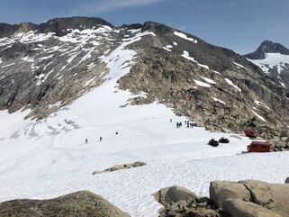
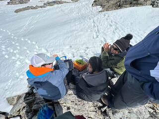
Kahiltna Glacier and Begguya Plateau, Denali National Park and Preserve, Alaska
June-July 2023 GPR Science Lead Our team (Emma Erwin, Claire Bicknell (Alaska Mountaineering School guide and Alaska Pacific University student) and myself) traversed the lower half of the West Buttress route to Denali (highest peak in North America!) to acclimatize for our upcoming geophysical surveys on the Begguya (Mt. Hunter) summit plateau (12,700ft). The traverse from Denali Base Camp (7,200ft) to Camp 2 (11,000ft) took us three days to complete. During the traverse, I towed a shallow, high frequency (900MHz) ground penetrating radar system (GPR) in a sled behind me with the rest of my gear. The goal of towing this ~50lb system up to 11,000ft was to investigate how the near-surface properties (upper ~20m) of the snowpack change with elevation. The Kahiltna Glacier offers one of the most magnificent elevation gradients to study with more than 12,000ft of relief. This gradient allows us to study the transition from wet snow at lower elevations to dry snow at higher elevations, which can be difficult to study in other locations. To our benefit, this route is well-traveled. The traverse consisted of many, many whiteouts and hard days climbing steep gradients but left us with magnificent views once we arrived at Camp 2. We remained at Camp 2 for over a week as we waited for a weather window to fly up to the Begguya summit plateau. Once we received word of an opening in the weather, we packed up and attempted to ski back to Base Camp. We made it to 10,000ft before finding ourselves in a freezing rain storm that lasted two days. Upon arriving at Camp 1 (7,800ft), we were shocked to find our flagged cache had disappeared. So what did we do? We did what we do best - we used the GPR system in an attempt to locate our missing cache. Unfortunately, our high-resolution grid survey of our old campsite and surrounding area yielded no results and our cache was gone. The second goal of my research was to conduct GPR surveys and snow density measurements on the Begguya summit plateau to validate our data from the Kahiltna. Unfortunately, the weather continued to work against us and we were unable to complete the surveys. We did excavate a 4.15m snow pit, but high winds and snowfall resulted in the filling of the pit overnight before we were able to collect density measurements. Given the lack of science-able weather, we focused our efforts on our primary objective: collecting a fine scale (10cm intervals) survey with the ApRES to constrain englacial stratigraphy and ice deformation at the location of the 2013 twin Denali ice core drilling site. The Kahiltna Glacier and Begguya are located on Dena'ina lands. To learn more about the surveys, please check out our field reports on the University of Maine Climate Change Institute's website (below) and Emma Erwin's website (below) for more information regarding the novel ApRES technique! |
Kahiltna GlacierBegguya Plateau |
Upcoming Work - 2023-24 Season
Maine Geophysics SurveysIn the winter 2023-24 season, we will test different ground-penetrating radar (GPR) techniques to better understand snowpack evolution and quantify snow water equivalent (SWE) in western and northern Maine.
|
Juneau Icefield Geophysics SurveysExtensive GPR surveys will continue on the Juneau Icefield through the 2024 season with the use of new radar technology to better understand snow and glacier hydrology, SWE, and ice dynamics.
|
Eaglecrest Geophysics SurveysIn the winter 2023-24 season, we will conduct GPR surveys at Eaglecrest Ski Area to better understand snowpack evolution and SWE. In summer 2024, we will install an upward-facing radar system at Eaglecrest Ski Area in Juneau, Alaska with supporting meteorological equipment to capture sub-daily changes in snowpack properties.
|
2019
|
|
Juneau Icefield Research Program, Juneau Icefield, Alaska
Student As a student with JIRP, I spent eight weeks traversing ~120 kilometers across the Juneau Icefield from Juneau, Alaska to Atlin, British Columbia, with ~30 high school and post-secondary students, staff, resident and visiting faculty and researchers from around the globe. Research Project
Part of the JIRP curriculum is to participate in a research project based on the subjects of ecology, hydrology, climatology, mass balance, geomorphology, geomatics or geophysics (which rotate through the years). I was part of the Geomorphology research group. Our group worked with Columbia University faculty, University of Vermont Cosmo Lab and Purdue Prime Lab to collect bedrock samples from nunataks (bedrock outcrops) on the icefield and analyze their beryllium concentrations. The amount of beryllium in the rock can tell us approximately how long the rock has been exposed (alternatively, when the surrounding ice retreated from that area). This work is helping to further constrain the deglaciation history of the Juneau Icefield. The Juneau Icefield is located on Lingít Aaní, Taku River Tlingit and Haida lands.
|
